In Part 1 of this series, we explored how fiber mapping software can optimize both CapEx and OpEx by improving accuracy, streamlining operations, and reducing unnecessary expenses. Now, let’s take a closer look at how 3-GIS software and services specifically address these challenges—helping network operators accelerate deployment, minimize costs, and maximize returns.
Driving CapEx efficiency with precision and automation
Investing in fiber infrastructure requires meticulous planning—every connection, splice, and route must be carefully designed to avoid unnecessary costs and inefficiencies. But even the best plans are only as good as the data behind them.
With 3-GIS | Web, operators have a centralized platform for real-time, GIS-based data management, ensuring accurate asset placement and seamless alignment using geospatial insights. This level of accuracy helps prevent costly overbuilds, misalignment, and material waste—key factors in keeping projects on schedule and making the most of available funding amid labor shortages and supply chain delays.
Beyond accuracy, financial accountability is also key, especially for operators participating in initiatives like the U.S. Broadband Equity, Access, and Deployment (BEAD) Program. The BEAD Program requires grant recipients to submit an Initial Report within 90 days of receiving funds, detailing planned and actual fund usage. Additionally, recipients must provide Semi-Annual Reports every six months, outlining progress and financial expenditures. Timely and accurate reporting is essential to maintain compliance and secure ongoing funding.1,2
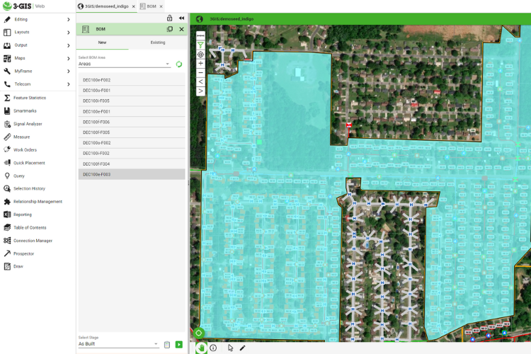
To further support cost efficiency, 3-GIS | Web helps operators optimize material usage by generating bills of materials (BOM) based on configurable project rules. This allows teams to allocate resources efficiently and avoid over-purchasing to keep CapEx under control.
 Sample bill of materials (BOM) generated in 3-GIS | Web
Building on this foundation, 3-GIS | Prospector extends the capabilities of 3-GIS | Web by acting as a GPS for network operators—automating and optimizing route selection with intelligence. By leveraging advanced algorithms, Prospector accelerates network planning, reducing the time and labor required for engineering. Operators can generate least-cost routes, receive cost estimates, define areas to avoid, and analyze premises passed to pinpoint the best investment opportunities.
With data-driven, decision-making tools, 3-GIS | Web ensures network investments are strategic, cost-effective, and less prone to human error.
Lowering OpEx with smarter field management
Once a network is built, keeping operational costs low is essential for long-term success. One of the most effective ways to reduce OpEx is by minimizing truck rolls. Collaborative fiber mapping software helps achieve this by equipping field crews with the data needed for the job at hand.
3-GIS | Mobile, for example, enhances workforce productivity by providing field teams with real-time, location-based network data—anywhere, anytime. Instead of relying on static paper maps or outdated records, technicians can access up-to-date asset information, run reports, and pinpoint outage locations directly from their mobile devices, ensuring faster, more informed decision-making in the field.
 Viewing asset information in 3-GIS | Mobile
SSP Vision, an AI-powered, field-optimized application, takes efficiency even further by enabling precise data capture with the tap of a button. This ensures that assets are recorded correctly the first time—minimizing rework, reducing errors, and maximizing operational efficiency.
Transforming the bottom line with scalable, cloud-based solutions
Beyond reducing CapEx and OpEx, cloud-based fiber mapping software drives long-term ROI by enabling scalable growth. Expanding network infrastructure often requires scaling physical hardware—adding even more complexity and cost to an already challenging task.
That’s where 3-GIS’s cloud-based architecture makes a difference. As networks grow, the software adapts—eliminating the need for frequent system upgrades or replacements. Because it runs in a web browser, IT teams no longer need to update individual user machines, ensuring everyone always works from the same version. (Prefer to keep your infrastructure on-premises? 3-GIS supports that too, while still giving users seamless web-based access to the software.)
Integration capabilities further enhance efficiency by connecting 3-GIS | Web with existing business support systems (BSS) and operations support systems (OSS). By aligning fiber network management with broader organizational goals, operators can streamline workflows, improve efficiency, and maximize financial impact—all while maintaining an agile, future-ready network.
For telecom operators looking to control costs and improve network performance, investing in the right fiber mapping software is critical. 3-GIS not only provides the tools to optimize network planning and management but also delivers the automation, accuracy, and scalability needed to drive real financial impact. Want to learn more about how 3-GIS's fiber mapping software can support your network growth? Contact us today.
Citations:
1National Telecommunications and Information Administration (NTIA), BEAD Initial Report Guide Slide Deck, U.S. Department of Commerce, 2024, https://www.ntia.gov/sites/default/files/funding_programs/program_documentation/bead-initial-report-guide-slide-deck.pdf.
2National Telecommunications and Information Administration (NTIA), BEAD Semi-Annual Report 1.1: Guide for Grantees, U.S. Department of Commerce, 2024, https://broadbandusa.ntia.gov/sites/default/files/2024-07/BEAD_Semi_Annual_Report_1.1_Guide_for_Grantee.pdf.