3-GIS works with telecommunications and engineering companies worldwide to help them plan, design, and manage fiber networks. Clients range from having one user in an organization to thousands. Having such a broad customer base is a blessing, but it can cause confusion about the true scope of capabilities of 3-GIS | Network Solutions. 3-GIS Co-founder Tom Counts was the subject of a recent interview where he had the opportunity to address some of these common questions and misconceptions about the solution.
Q. Who is the target customer for 3-GIS| Network Solutions?
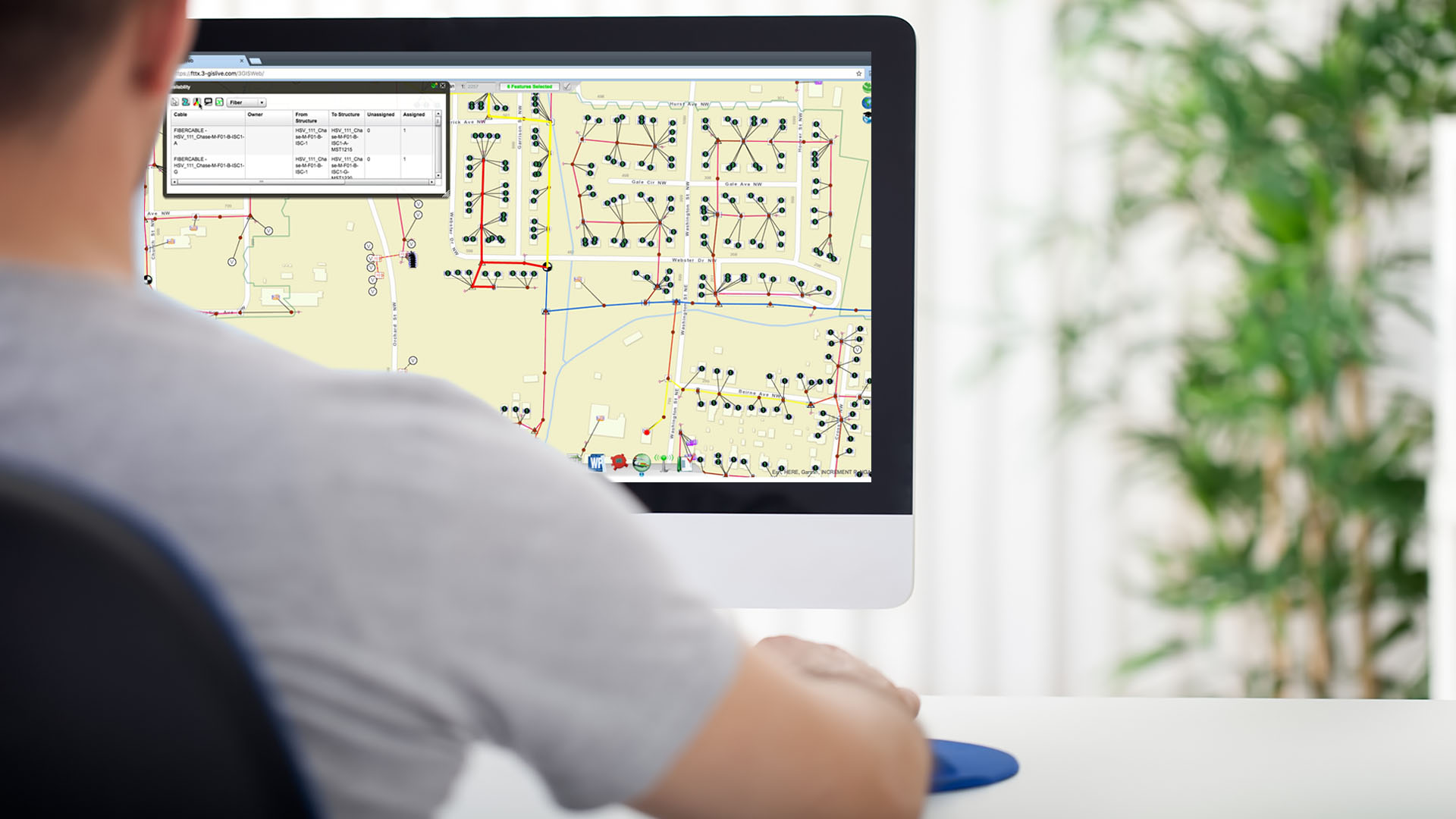
A. 3-GIS|Network Solutions has a very broad reach for an AM/FM/GIS solution. While this market has historically marketed and sold to the Engineering and Operations divisions within a telecom provider, 3-GIS|Network Solutions begins at the planning stage and supports the customer all the way to retirement of plant. What I mean, is that 3-GIS|Network Solutions is a “solution” and not a product. It supports planning, route analysis, demand analysis, initial design, construction ride-out, final design, make-ready, and construction. Furthermore, it comfortably and affordably can sit on every desk (and truck and hip) of the enterprise to share network and asset information in real-time. The market has historically been relegated to thick desktop clients limited to design and construction only.
Q. Does 3-GIS| Network Solutions effectively manage a fiber network today?
A. That’s a 1999 question. Why do I say that? Because desktop solutions have been built in the past to support a topology or network type. 3-GIS|Network Solutions is not a “model driven” approach. Been there, done that, didn’t work too well. When I say didn’t work too well, it actually worked great if you had perfect data and a legion of engineers that could build models, but that’s not realistic.
We built a system meant to last—3-GIS | Web—that isn’t restrained by a particular model of equipment (plant). What that means is, 3-GIS | Web is highly flexible and can support any manner of connected network models. The system is designed to manage today’s fiber networks and to be easily adaptable—to manage the fiber networks of the future. But, it can also be configured to pull in data for copper, wireless, gas, electric, water, you name it. And as muni-fiber continues to gather momentum, the value in that statement continues to grow.
Q. You mentioned your ability to scale. Easy to say is easy to say. Can you explain that?
A. When we were building desktop systems, we were trying very hard to create a system to support enterprise level consumption—to the point of country-wide in one instance in the UK. We ultimately got up to around 4,000 complex edits a day (posted and reconciled) but consistently ran into one wall or another. Now, we’re supporting up to 60,000 edits a day in our 3-GIS|Live model of 3-GIS | Web. 3-GIS|Live is our cloud-hosted solution supported by Amazon Web Services (AWS). It’s awesome, by the way. So yes, the ability to scale is one of the biggest strengths that sets us apart from other systems.
Q. Is your ability to scale simply by virtue of throwing mountains of compute power at your software?
A. Not at all. We’ve invested hundreds of thousands of dollars perfecting our architecture which enables our system to scale in a highly efficient manner. If we didn’t, we couldn’t be cost competitive in the market. We have worked tirelessly with Esri and Amazon to develop an incredibly scalable, secure, and efficient delivery model.
Q. Well, that opens up two more questions. Tell me about security, and tell me about costs.
A1. I can tell you it’s monitored 24/7/365, and we have third parties conducting penetration testing on it 24/7/365, as well. The second a new vulnerability is discovered (or introduced by upgrades, patches, etc…), they’re immediately discovered and plugged. No rest for the wicked, so no rest for 3-GIS.
A2. Cost is an interesting subject. When you compare us to a desktop solution, we’re highly competitive once you hit 3-4 users. But the value of our system goes so much deeper than traditional desktop systems. In today’s competitive and efficiency driven environment, you’ll save time, money, and frustration by sharing the data across a larger landscape of users, making the true total cost of ownership fractional when compared to a traditional desktop approach.
Q. I’m guessing you’re really talking about the 3-GIS|Live economics when you talk costs?
A. One would assume so, but not entirely. I’m talking 3-GIS|Network Solutions in either an on-premises or cloud-hosted model. If you have a strong IT infrastructure and a team of IT folks, then by all means, keep it on premises if that makes sense for your organization. The initial price may be higher, but the year-on-year costs will be lower using a traditional on-premise maintenance model. However, if you’d rather 3-GIS take care of the concerns about data-security, backups, performance, infrastructure, upgrades, tuning, and optimization, then 3-GIS|Live is the way to go. After about 5 years, the on-premise and cloud-hosted model will cost you about the same.
Q. When you talk about sharing data across a landscape of users, what roles are you talking about?
A. First, we provide a very solid solution for the network engineer. That was our first priority when designing our innovative solution, and we meet all the expected functionality of an outside plant (OSP) engineering solution. However, we also have some great planning, design analysis tools, quality assurance, and bill of materials tools. On top of all those capabilities, we include a very capable integrated mobile solution, 3-GIS | Mobile, to allow your field technicians to evaluate, construct, audit, or just be informed about your corporate assets. And, when I say assets, I’m not just talking OSP. I’m taking about other technicians and customer information as well.
Our solution really is an enterprise-wide solution for asset management, engineering, and design, but it goes so much deeper. It helps users understand things like network efficiency and utilization, how to provide the best service to customers at the lowest cost, and ultimately, it gives users a simple way to view and interpret data not only about the physical network, but also about the customers and opportunities that exist around it.
Q. I notice you use the word innovative a lot. Tell me what’s so unique about 3-GIS|Network Solutions that makes it not just another software?
A. Finally, an easy question! We’re the first 100% web services product to provide a full-editing experience for the telecom professional. By designing a web services architecture, we truly provide a modern architecture that can talk, or interface, with other systems without performing some unnatural act or spending hundreds of thousands of dollars creating special APIs or pair-wise interfaces. Furthermore, by developing our own custom UX, or User Experience, we have developed a completely unique approach that is NOT an engineer’s (CAD) or cartographer’s (GIS) environment corrupted into something it’s not comfortable doing.
Q. Isn’t that really a weakness? Aren’t you really keeping a lot of functionality away from the telecom engineer that he/she might sometimes want or need?
A. Since we store all of our data in a standard Esri Geodatabase, you can always get right to it with the GIS-specific Esri products whenever you need it. However, why deliver that expense (in cost and complexity) when it’s seldom used? Possibly even NEVER used by 90% of your engineers. So, for those 10% that do, spend the money for a few desktop seats of ArcGIS, and you’ll be good to go. But don’t spend the money on every desktop when it’s not necessary. Our architecture is totally open. When you need to access it with other products, analyze it with other tools, or massage it with third-party applications, we’re fine with it. We don’t confine our customers to a proprietary architecture, data schema, or data storage methodology. Although we have a strong ecosystem, there are always going to be certain tools or partners that do things a little better. So why prohibit you from using them?
Q. This whole discussion began around depth of the product so let’s go there finally. We can do this quickly; I’m going to mention a feature and I need to know whether you can do it or not. I don’t want a lot of weasel words. You either do it or you don’t. Let’s go:
|
1. Creation and editing of features |
Yes, including precision placements |
|
2. Ability to modify geometry |
Yes |
|
3. Manage multiple layers of data |
Yes, local and online |
|
4. Ability to trace networks |
Yes, fastest in the world |
|
5. Signal/OTDR calculations |
Yes |
|
6. Leased vs owned fiber management |
Yes, and contract management |
|
7. Support for GPON |
Yes, plus other technologies |
|
8. Schematic generation |
Yes, multiple |
|
9. Inside plant |
Yes |
|
10. Reporting |
Yes, multiple, including splice and signal |
|
11. Printing |
Yes, WYSIWYG and plots |
|
12. Conduit Management |
Yes, with visual capacity displays |
Q. Okay, I get it. You’re just like the rest.
A. No! Who else can train you on their system and have you competently using it in less than a day? Our system is easy to use and uncomplicated —partly because we don’t try to be too many things at once. We’re a fiber management system focused on managing fiber; full stop. We’re not an architectural or cartographer’s tool, so we’re not complex. We train quickly, and our adoption during conversion from CAD or GIS is incredibly high. By virtue, we’re nothing like the rest. Being a web-based product, focused on fiber, on an open architecture (no custom features or stored procedures), there is absolutely nothing like us in the market right now. Sure, we took a big departure from status quo, but that’s what happens when you embrace web services in a complex market.
Q. Any final comments about the “depth” of your product…excuse me, your solution?
A. Sure, if you want to measure depth by complexity, I’d have to say we’re not very deep. From the first time you see our products to the tenth time you use it, you’ll find it uncannily predictive, non-threatening, and generally user-friendly. I remember when I was in my mid-20’s, I bought a 1989 McLaren Grand Prix. I bought it because a) it had tons of power and b) it had more buttons than the Space Shuttle. I thought the more buttons, the cooler it was. As I’ve aged, I’ve realized that complexity is not something to embrace. My current car does way more than that 1989 Grand Prix, but it has a third the number of buttons and is much less confusing. Cars have evolved. Why hasn’t our software?
Jack Trout said it best in The Power of Simplicity; "Complexity is not to be admired. It is to be avoided." We did it. We have equivalent—if not greater depth—in many areas compared to our competition, but the path to get there is not nearly as confounding as it used to be. Our solution was truly built to be simple, smart, and intuitive.
Q. Well, I think I’ve exhausted the subject for now. Are there any closing statements or thoughts you’d like to share?
A. Sure and thanks. I’ve enjoyed this and am happy to be coming up on our 10th Anniversary. We’re no longer a start-up, although I still feel that way every day, so any concerns about 3-GIS being too small should be something to set aside. We’ve been innovating from day one and will continue to do so for a long time to come. We love what we do, we have fun doing what we do, and we hope you’ll give us a chance to show you how you can too. I’ve heard our system described as "totally unexpected and totally refreshing." That, to me, was the greatest compliment we could get. Recently recognized by Inc. as one of the fastest growing companies in the US and by Broadband Communities as one of the Top 100 companies in Fiber-to-the-Home, I think we’re truly hitting our stride. Thanks for your interest today.